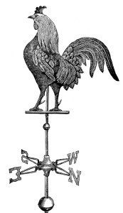
Who did this handsome bird belong to? The apparent answer is James Kelburn, but the truth is trickier.
This particular cock first showed up in Dublin in August 1748. It appeared on a blizzard of polemical pamphlets turned out by the apothecary and radical campaigner Charles Lucas during a Dublin by-election campaign. Lucas was an Irish protestant patriot who had for years been arguing for reform of the Dublin corporation, run by a self-perpetuating club of unelected aldermen. They were in the habit of nominating MPs from among themselves, and in 1748 both members of the Irish parliament for Dublin were also aldermen. One of these two happened to die on 16 August 1748, two days before Lucas put his signature to a municipal reform pamphlet entitled To the free citizens, and free-holders, of the City of Dublin. It was published by a Dublin bookseller named James Kelburn.
Lucas declared his intention to stand for the vacant seat (it would be a 14-month campaign because the writ for the by-election could not be issued until the next session of parliament in October). On 27 August he brought out another pamphlet, named A second address to the free citizens, and free-holders, of the City of Dublin. There would be twenty of them altogether. The first had an unremarkable printer’s ornament on the front. On second edition of the first pamphlet this bespoke fighting cock had replaced the flowers, and it remained there on all the following nineteen addresses.
The inscription – pro patria pugnis unguibus et rostro – ought to be a clue. It translates as ‘for country with fists, claws and beak’ or perhaps ‘fight for country with beak and spurs (our bird has a fierce-looking pair). Voltaire used it as he launched his Traité sur la tolérance on the world in 1763: ‘défendez la bonne cause, pugnis, unguibus et rostro’. He was scolding Jean d’Alembert for ducking out of a fight against the powers of church and state in France over the Encyclopédie the latter had worked on with Diderot (who was still trying to finish it clandestinely).
Without going back as far as the classical poets, where the Latin half of Voltaire’s rallying cry seems to originate (Ovid’s bird was a vulture), the line can be traced to an earlier French provocateur. Voltaire may have been quoting the satirical Molière – but too late to have inspired the words on the Dublin emblem. They probably came straight from Molière. In Le mariage forcé, he has Pancrace say ‘je défendrai cette proposition, pugnis et calcibus, unguibus et rostro’ (I’ll defend that proposition, fists and heels, claws and beak). The play appeared in Paris in the 1660s. Molière’s works in an English translation were published in London in 1714; a French–English parallel text of Le mariage forcé appeared there in 1732 and was reissued in 1748.

The play does not seem to have been performed in Dublin in the 1740s, but it would certainly have been known. When Lucas was rattling out his election pamphlets, the Smock Alley theatre was run by Thomas Sheridan (godson of Jonathan Swift and father of Sheridan the playwright). He, like Molière, was an actor-manager. In 1737 Sheridan staged his farce entitled The Honest Irishman, which reappeared through the 1740s as The Brave Irishman: or, Captain O’Blunder. It was an adaptation (via Congreve) of another Molière comedy, Monsieur de Porceaugnac. Sheridan, who had known the London theatre world since his teens at Westminster school, went there often to hire acts for Dublin. He and Lucas were friends.
In 1747 a drunken young ‘gentleman’ climbed out of the pit at Smock Alley and went backstage where he sexually assaulted two women. Sheridan had him thrown out, but the drunk caught up with him later demanding an apology and yelling insults at the theatre manager, whom he saw as a social inferior. At that point Sheridan finally cracked and hit him with a stick. Two days later about fifty young gentlemen launched a riot in the theatre. In the resulting public furore Lucas supported Sheridan.

Molière takes care of the campaign slogan, more or less, but why the fighting cock? Lucas was in earnest about the corruption of Dublin politics, and set out (at enormous length) the history and workings of the British constitution and its abuse by an oligarchy in Ireland. But maybe the cock was an elaborate pun?
Lucas’s most vitriolic opponent in the pamphlet wars was the pseudonymous Anthony Litten. ‘An old Irishman, one Mac Cruttin … positively insists, the Name Litten, is derived … from an Animal well known in this country … I think he called it, KELLITEEN, which in our language implies, a dastard, or a Dung hill Cock, or Cocks.’ That was Lucas, facetiously citing the Irish scholar and poet Aodh Buidhe Mac Cruitín, who in English wrote as Hugh MacCurtin. Kelliteen is an anglicised version of coilichín, a cock. MacCurtin and Lucas may have cooked that one up together.
Anthony Litten was a pen-name of Sir Richard Cox, MP for Clonakilty, who entitled his blasts against Lucas The Cork Surgeon’s Antidote, against the Dublin Apothecary’s Poyson. He was also a grandson of Sir Richard Cox, lord chancellor of Ireland, whom Lucas accused in print of having had MacCurtin jailed.
Lucas’s bird first strutted in August 1748. Anthony Litten appeared in print a year later, when the cock (to fight two others?) was long fledged. It had already been spotted. In November 1748 a satirical pamphlet appeared, written (by Paul Hiffernan, an enemy of both Lucas and Sheridan) in the form of a last will and testament of Mr C—s L—s :
‘I resign my Soul to the Regions allotted for Spirits of high Views and curious Researches … and should there happen to be any Truth in the Pythagorean Doctrine, I hereby intimate my Desire, that my Soul should lodge in a Cock: a Bird, for whom I have the greatest Respect, as you may find in the Title-Page of all my Addresses; and thus shall I retain my Vigilance, my Readiness for Fight even with my Shadow, my Crowing victorious or defeated, in Time and out of Time: but the chief Reason of my Fondness for this Bird is, that it is the only Species of Creatures, among whom Blinkers are in any Sort of Reputation.’ (Blinkers were fighting-cocks blind in one eye.)
Lucas’s earliest election pamphlets were probably printed by Edward Bate, whose shop, like Kelburn the bookseller’s, was in George’s Lane. The ornament on the two earliest 1748 Lucas pamphlets also appears on an unrelated work printed by Bate. Another very similar cut has a fighting cock in the centre rather than a bowl of flowers. That one’s an oddity, because instead of a comb the cock wears what looks very like a Cap of Liberty or bonnet rouge, emblem of the French Revolution that was yet to come.


Le coq gaulois had been a symbol of the French nation since they were Gauls (it’s an old pun on the word gallus). The cap or something like it was known in antiquity as a symbol of freemen, and the bonnet rouge was the emblem of a 1675 tax revolt in Brittany against Louis IV. This particular cock showed up in London in 1724, on a pamphlet entitled Bishop Burnet’s proofs of the Pretender’s illegitimacy, by George Wilson.

Lucas the Dublin patriot may have been reading the Roman historian Tacitus on abuses of power. The bird above appeared in 1732 in translations of Tacitus by a radical Scottish Whig pamphleteer named Thomas Gordon, as a tailpiece under his discourse on Tacitus headed ‘Of Princes’ which was printed in London (a Dublin version had different ornaments). A collection of Gordon’s pamphlets on the Jacobite rebellion (volume 4 of the Independent Whig) was reissued in Dublin by James Kelburn in 1748.
Then there are the geese. In May 1749 the tireless Lucas published The Great Charter of the Liberties of the City of Dublin, in English and Latin, modelled on Magna Carta. It is illustrated with four coats of arms done by the Dublin engraver Philip Simms, presumably to Lucas’s specification. The oddest of the four has the familiar three towers of the city of Dublin on the escutcheon, but the supporters are a hissing goose and a cock. The motto below is VIGILANCE AND VALOR (surely an improvement on the real Dublin Corporation motto, which translates as ‘the obedience of the citizens is the happiness of the city’). The cock represents valour, while the goose refers to the geese that woke the Romans and thereby saved the ancient city. From the Gauls, as it happens.

By that time Lucas was in trouble for sedition. His tenth address had included the following: ‘it must now be confessed that there was no general rebellion in Ireland, since the first British invasion, that was not raised or fomented by the oppression, instigation, evil influence or connivance of the English’. By February 1749 James Kelburn had judiciously removed himself from the imprint, to be replaced by James Esdall who was both a printer and a bookseller, but the fighting cock with its Latin motto remained on the front throughout the series and beyond. The woodcut block must have belonged to Charles Lucas himself, who probably designed it and had it cut (by an unknown hand), then brought it with him to whichever printer was willing to take the risk.
In October 1749 Lucas, Kelburn and Esdall were summoned to appear before the Dublin Commons to answer a complaint made by Sir Richard Cox that Lucas’s writings justified ‘the bloody and barbarous rebellions’ in the kingdom, and tended to create jealousy between Great Britain and Ireland. Esdall absconded, while Kelburn did appear and admitted he had published the first eleven addresses – he could hardly deny it since his name was on them. Lucas also presented himself and argued his political case but refused to incriminate himself. He had energetic support among merchants and tradesmen, but once it was clear he would be arrested and jailed he was obliged to leave Dublin in a hurry.
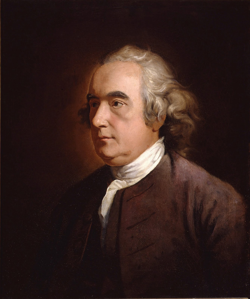
Lucas spent eleven years in exile. First he travelled to England, then on to Paris, Rheims and Leiden where he studied medicine. In 1759 he was admitted as a licentiate to the Royal College of Physicians of London. On the accession of George III in 1760 he was free to come back to Dublin, and the following year he was elected to the Irish parliament. That was probably when he had his portrait done.
As for what inspired Lucas in 1748 to choose a cock for his emblem, it could have been something as simple as a weathercock, or a street sign. Dublin had quite a few. A goldsmith and bookseller named Charles Leslie, for whom Edward Bate printed, had his shop at the sign of the Cock in Castle Street. Lucas lists him in 1749 in A letter to the free-citizens of the city of Dublin, although not among those he singles out as having proved themselves ‘honest and free’ – in other words Leslie was not one of his political allies. But then nor was Richard Cox.
A classicist or an Irish scholar might have a more convincing explanation for this bird. The emblem accompanied Charles Lucas to the grave. It was reported that at his funeral in Dublin in 1771 a cock was emblazoned on the pall. He died an Irish patriot, if never quite a republican.
Some further reading
Vincent Morley, An Crann os Coill: Aodh Buí Mac Cruitín, c. 1680–1755, Dublin, 1995 [in Irish]
Sean Murphy, ‘Charles Lucas and the Dublin Election of 1748-9’, Parliamentary History, 2, 1983, pp. 93–111
Sean J Murphy, A forgotten patriot doctor: Charles Lucas 1713–1771, 3rd edn [online], 2015
Esther K Sheldon, Thomas Sheridan of Smock-Alley, Princeton, New Jersey, 1967