I’m thinking about going to Gloucester. It’s one of the great unpronounceables, unless you heard it spoken before ever seeing it written down, in which case it may be unspellable instead.
The unpronounceable part began in ancient Britain with the plain and forthright Glev, was latinised by the Romans to Glevum castra (a camp or fort), then got complicated when it travelled through the Old English of the Anglo-Saxons, as Gleávan ceaster, to become Gloucester, according to the author of The Place-Names of the English People ( M J C Meiklejohn, writing in 1929 – his Glev is guesswork). Its fellow Mercian towns Leicester, Bicester, Cirencester and Worcester came the same way; Meiklejohn supposes that difficulty pronouncing them led to a tendency to slur, resulting in Gloster, Lester, Bister, Ciceter and Wooster. Evolution, rather than incompetence, would be a less prescriptive view of what happened.
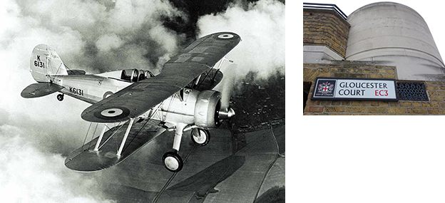
The Gloster Gladiator’s manufacturer began as the Gloucestershire Aircraft Company. Overseas customers had difficulty with the first word so the company changed it to Gloster. But the ducal form is everywhere. And Ciceter? That was Shakespeare’s version in Richard II, three syllables (not to be confused with Chichester – or Chy-chester, heard in a Belfast street in the 1970s, perhaps no longer). Since 1929 Cirencester has evolved again, to be spoken as spelled.
The lexicographer Noah Webster of Connecticut first made a case for rational spelling in the 1780s – spell as you speak. He regarded British practice as undemocratic. In the 1800s there was an outbreak of dictionary wars, when a younger American countered Webster’s dictionaries with his own, preferring traditional spelling. His name? Joseph Emerson Worcester.
Worcester or Wooster?
A case against rational spelling could be made in a similar way to arguments against straight roads in residential streets, or river-straightening. Cars and floodwaters rush through at speed flattening pedestrians and bridges; the mind races through simplified spellings getting no grip on the evolved shapes and resonances of words. It’s easier to spell them but harder to understand them, and the trace of their history is lost.
There is a related difficulty with prescribing simplicity for children – and often their elders: given a chance they tend to prefer complication. Young children are fond of puns and messing about generally with the sound of words. Short names get longer nick-names. Rhyming slang does the same thing – jam jar (car), currant bun (Sun), J Arthur Rank (bank, possibly).
On the other hand there’s Doctor Foster, who went to Gloucester in the nursery rhyme – although in an early appearance, in Gammer Gurton’s Garland, it was Glos’ter. This Gammer Gurton was nobody’s grandma; the anthology was first published in the late 1700s by the antiquarian and republican Joseph Ritson from Stockton-on-Tees, who was an advocate of phonetic spelling. ‘Dr Forster went to Glo’ster’ appears only in an augmented edition by Francis Douce, published after Ritson’s death – Ritson might have omitted the apostrophe. He and Webster had a point: to keep to Old English spelling does amount to aristocratic nonsense, when you think about it.
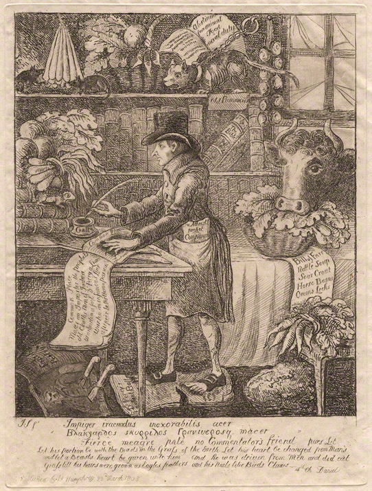
Joseph Ritson, not being taken seriously by James Sayers, 1803 [National Portrait Gallery]
The Downs is an odd name for a stretch of seawater. Located off Deal on the east Kent coast, it was once described as ‘the great road of England’[1] and served as a vast open water anchorage, protected from French and Dutch fleets in the Channel by the shoals of the Goodwin Sands. William Camden admired its amphibious working population:
… those especially which dwell by the roads or harboroughs of Margat, Ramsgat and Broadstear. For they are passing industrious, and as if they were amphibii, that is, both land-creatures and sea-creatures, get their living both by sea and land, as one would say, with both these elements: they be Fisher-men and Plough men, as well Husband-men as Mariners … Furthermore, whereas that otherwhiles there happen shipwrackes here (for they lie full against the shore those most dangerous flats, shallowes, shelves, and sands so much feared of Sailers, which they use to call The Goodwin Sands, The Brakes, The Four-Foots, The Whitdick &c.), these men are wont to bestir themselves lustily in recovering both ships, men, and Marchandise endangered.[2]
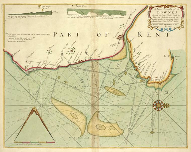
The name is said to be derived from the topography of the land it faces: the North Downs, a long rib-bone of chalk that juts up out of the clay of south-eastern England and is cut through by the sea between Dover and Folkstone.[3] However, on closer inspection the link between round chalk hill and sea anchorage collapses. From the deck of a ship in the Downs, the hills that form the eastern end of the North Downs range are apparent only where they end in sea cliffs: the ridge of the escarpment is about 16 miles away with its flat back turned squarely to Deal. Greenvile Collins’s Large Draught of the Downes, above, includes an elevation of the coastline between Walmer Castle and the South Foreland. The horizon is flat, with dipping white cliffs appearing below it. Camden mentions ‘the North downs toward the Tamis’ as the place for rabbit-hunting, and in 1665 the diarist John Evelyn notes that ‘this country from Rochester to Maidstone and the Downs is very agreeable for the prospect’. But their Downs are away to the west, and the term does not seem to have been used for the hills near the coast until much later. On the other hand, references to the Downs as an anchorage go back at least to the fifteenth-century Gregory’s Chronicle: ‘Ande that same yere there was a grete wyntyr and a colde froste, that duryd fro Syn Kateryns day to Synt Valentynys day next sewynge, soo that noo schippe myght passe; wherefore the vyntage come by londe ynne cartys unto London fro the Downys’.[4]
What the shoreline of Sandwich Bay does have is sand-dunes, between the two chalk Forelands. Daniel Defoe in 1762 describes the ‘flat coast’ south of Sandwich as ‘fenced against the Ocean by the Sand-downs’; he also observes that that the town of Sandwich is noted for carrots.[5] Camden before him had recorded a careful account of the same coastline:
From this Fore-land aforesaid, the shore runneth on Southward for certaine miles together, indented with a continued raunge of many hilles mounting up. But when it is come as farre as Sandon (that is to say the Downe of Sand) and to Deale and Walmer, three Neighbour Castles which King Henrie the Eighth within the remembrance of our Fathers built, it setleth low and in a flat and open plaine lieth full against the sea … verily as soone as we are past Deale a mighty ridge of steepe high Cliffes (Cicero termeth them moles magnificas, that is stately cliffes) bringing forth Sampier in great plenty, runneth for seaven miles or there about as far as to Dover …
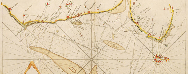
The sand does not stop there: the Goodwins themselves are shape-shifting underwater sand-hills, their tops dry at low water of a spring tide. Collins’s Large Draught was first published in 1693, and continued in use throughout the following century, during which the underwater hills evidently extended themselves and a new sandbank appeared just off Deal: see the detail below.
Head eastwards across the Channel – more sand. At the Battle of the Dunes of 1658, a contingent of Cromwell’s New Model Army, in a French-led assault on Dunkirk (dune-church), charged up a 150ft-high sand hill to take a position from Spanish and British Royalist defenders. (The British were led by the Duke of York, offering the seductive though doubtless false notion of a seaside location for the rhyme about the Grand Old Duke who was neither up nor down.)
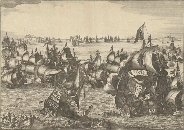
Down and dune are regarded as variants from the Anglo-Saxon word dún, a hill. The Dutch name for the Downs was almost the same: in 1639 their navy defeated the Spanish armada there, in an encounter known then to the English as the Battle of the Downs, to the Dutch as de Schep schlacht in Duyns, so named on a contemporary engraving by Crispijn van de Passe the younger (1597–1670). His battle scene has a very fanciful backdrop depicting a range of high choppy hills, the castles perched upon them. The print below depicting the same battle is from the studio of Claes Jansz. Visscher II (1586–1652), who was also a mapmaker and publisher; the downfall of the armada may be dramatised but the view of the coast is close to the truth.
The Battle of the Downs, studio of Claes Jansz. Visscher II
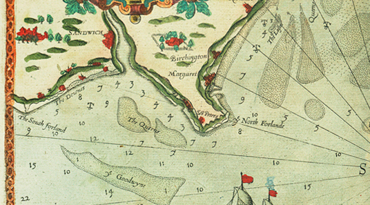
The last word comes from Lucas Jansz. Waghenaer in the previous century. The dunes behind the shingle beach, the anchorage and the name linking them are all shown on a chart in the 1588 English version of Waghenaer’s sea-atlas Spieghel der Zeevaerdt, below (more on Waghenaer here). The accompanying sailing directions for finding the safe channel inside the Goodwins, which appear in both versions, may be the real clue to how the Downs got its name:
If you come from the West, and will passe within the Goodwin to the foreland: first shape your course North north-east, and North and by East: and then the windmill standing westward of the Foreland, appeareth on the west side of the valley, hold then on North and by East, until you have brought the tower of the Foreland on the East-side of the sayd valley: and then you are on the North side of the Querns. The markes hereof are, when you see a litle tower standing on the forelandes point, and another on the Southforeland over against the third white downe at the castels side.
The ‘third white downe’ (de derde witte Duyn in the 1584 original) must refer to the undulating white cliff face that runs south from Walmer castle. The profile view of the cliffs included on the Waghenaer chart is sketchy and inaccurate, but Greenvile Collins [top] shows them precisely, with a lighthouse aligned on a dip in the cliff: ‘the Southernmost Swamp at A and the Light House in one is the best mark for the Gull Streame’. The Downs are most probably named not for a range of hills, nor for sand-dunes, but for the graphic shape of the cliffs between Walmer and the South Foreland.
Detail from The Mariners Mirrour, 1588
Notes
In an account, now lost, by Thomas Powell, one of the participants, of an appeal made to the Crown by a Deal parish committee in December 1698, that it might be incorporated as a borough and market town no longer subject to the jurisdiction and control of Sandwich. Quoted in Stephen Pritchard, The History of Deal, 1864, p. 146.
William Camden, Britannia, trs. Philemon Holland, 1610.
The Oxford English Dictionary makes this assertion but does not support it.
‘Gregory’s Chronicle: 1435–1450’, The Historical Collections of a Citizen of London in the fifteenth century (1876), p. 178.
Daniel Defoe, A tour thro’ the whole island of Great Britain, vol. I, 1762, p. 165.
The version of Greenvile Collins’s Large Draught of the Downes at the top of this post is in the New York Public Library and is dated to c.1702–7; the detail is from a later edition. The Visscher print of the Battle of the Downs is in the Rijksmuseum Amsterdam. The Mariners Mirrour (The English Waghenaer) is in the National Maritime Museum, Greenwich.